[This information is from pp. 81-91 of Shovel Ready: Razing Hopes, History, and a Sense of Place: Rethinking Schenectady's Downtown Strategies, a master's thesis in city planning by Christopher Patrick Spencer (MIT, 2001), and is reproduced with his permission. It is in the Schenectady Collection of the Schenectady County Public Library at Schdy R 711 Spe.]
Cities are an immense laboratory of trial and error, failure and success, in city building and design. This is the laboratory in which city planning should have been learning and forming and testing its theories.
Jane Jacobs, The Death and Life of Great American Cities
The end of the urban renewal era did not necessarily usher in a new way of thinking about old buildings or the speculative process of tearing them down and then waiting for developers to arrive. But after the last funds were squeezed out of that cash cow, wholesale demolition and assemblage of large tracts of land became tougher for Schenectady. The big project era, the string of faulty assumptions, and the unrealistic expectations for the city, however, did not end there. In fact, the grand conceptual visions and the big project approach continued — perhaps symptomatic of a condition that many "boom towns" based on one or two companies exhibit. Despite the long and colorful history of Schenectady, most of its development and population growth occurred in a span of about 30 years or more. The decline of the city and its downtown, however, happened much more slowly. But many in the city think that the city's resurgence will be as explosive as its early industrial growth. Perhaps they feel that because the city developed around one or two major companies, it will only take one or two major projects to save the city. This chapter will examine a few large building projects and track the continued but incremental loss of older and often historic structures due to the growth and proliferation of parking lots and the misconstrued need for street widening. It will also look at two projects that entailed selective demolition and adaptive reuse of existing structures. Despite the obvious need for the reuse of existing structures for such things as a civic center, the city plowed ahead with the destruction of buildings and the creation of parking lots throughout and well after the time when most cities had abandoned the old urban renewal ways.
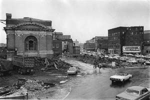
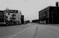
State Armory Near Crescent Park

Fig 7.01 [enlarge]
Armory once marked the top of Crescent Park and the intersection of Nott Terrace, Veeder Avenue, Albany Street and State Street.
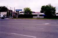
In 1947, as the city was beginning its Town of Tomorrow campaign, it demolished the old State Armory at the head of Crescent (now Veterans) Park. The armory, "a mixture of old English castle and Romanesque architecture," had been in service less than fifty years. It was Schenectady's second armory and the second at that location. Construction on it began in 1898. It was designed by the renowned state architect Isaac Perry and hailed as "one of the finest in the state at the time. It is a building of magnificent proportion and a welcome addition to the city." (1) The old armory had been the site of numerous civic gatherings. During the time of its demolition, the Town of Tomorrow Plans were calling for large tracts of land to be cleared in the city hall area to make way for, among many things, a new civic auditorium that could be used for large gatherings by the community. A few had suggested reusing the armory, but those ideas received scant attention at the time. The proposed civic center was never built, unless one considers Center City (described as a skating rink/civic center) as the realization of that idea. In 1936, Schenectady's third State Armory was constructed just southeast of the Van Curler Hotel (now Schenectady County Community College) on Washington Avenue. This new Art Deco/Tudor Revival edifice was designed by State Architect William Haugaard. In 1972, Mayor Frank Duci had suggested that it be converted into a civic center, an idea that never came to fruition. (2) In December of 1994, it was listed on the National Register of Historic Places and is still used by the National Guard.
By the end of 1947, the armory at the head of Crescent Park was gone. This cleared the way for Nott Terrace and Veeder Avenue to be widened and aligned with one another. The loss of the armory was not only a missed opportunity for the reuse of a great space, but it had previously helped frame and define the intersection where a number of important streets converge. Clearly it was not a building that was obsolete or deteriorated beyond repair but unfortunately one which did not capture the imagination of Schenectady's leaders at the time.
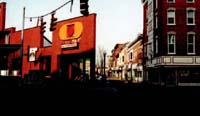
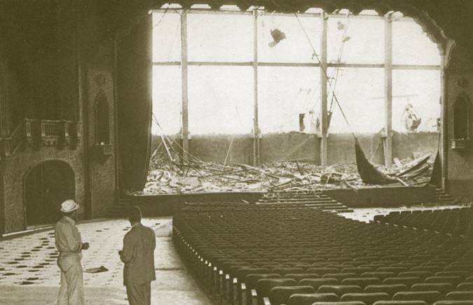
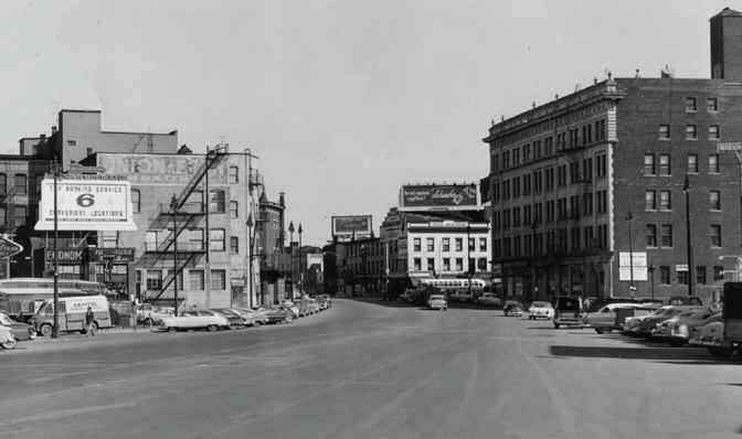
Plaza Theater
Less than 100 yards from the old armory stood one of Schenectady's great theaters, the Plaza. Built in 1931 it was active for a number of years. It provided part of the physical enclosure for Veterans Park and a number of active users for the park as well. The narrow front of the theater was part of the composition of buildings that gracefully followed the curve of State Street and stepped down the hill. After the theater closed, the city expressed concern that the owner was not maintaining the property. In 1964, after much pressure from the city, he removed the old theater. The site sat vacant for a number of years. Eventually many of the other buildings that had also been part of the composition of that street wall also were demolished. This cleared the way for the site to be used for parking. Forty-six years later, a new building is being constructed on the site where the theater and other buildings once stood. During much of this time, the idea of a civic auditorium continued to be talked about, but it was usually tabled as too expensive or just not feasible.
State Theater
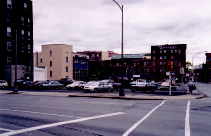
In the late 1970s, the State Theater on the corner of State Street and Erie Boulevard was leveled to make way for more parking and perhaps to honor the parking lots that were being created across the street near the train station. In 1974, a group of architects and other professionals that were part of the FOCUS Redevelopment Corporation "warned against demolition of the State Theater Arcade" noting that the privately owned theater-arcade provided one of the two remaining 'public assembly halls' in the city." (3) The marquee and the entrance on the corner of Erie and State survived and the marquee is used for advertising today. The theater itself is gone. It had extended back to Liberty Street and helped to physically define that corner. The buildings directly across from Liberty Street were removed around the same time to make way for a fast food hamburger establishment. Of the four corners that make up that intersection, only one is graced with a building — a one story grey-painted Burger King with a large parking lot and a drive-up window.
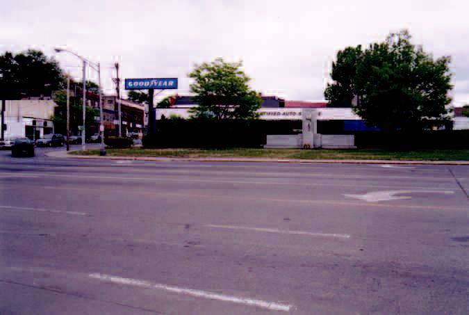
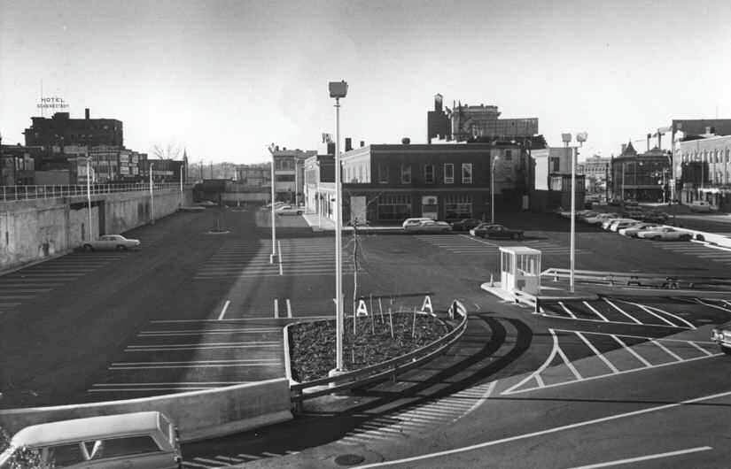
Union Station
In 1967, it became official that Schenectady would no longer be a stop along the New York Central Railroad. Instead a new suburban station would be built along Karner Road in the Town of Colonie. In rendering its decision, the New York State Public Service Commission [PSC] stated that the expenditure of $67,700 in needed repairs to the Union Station could not be justified given the low patronage and the fact that "the City of Schenectady appeared to be primarily concerned with the demolition of the existing building rather than having its use continued for passenger purposes." (4) In 1970, the city agreed to buy the station from the Pennsylvania Central Transportation Company for $20,000. (5) By July of 1971, cranes were in place working on the $121,000 job of demolishing the station to make way for parking for downtown shoppers. Watching the action, a senior public works inspector for Schenectady called it "just an exciting moment, that's all." (6) By 1976, plans were underway to build a new Amtrak station at the same location. (7) The station that was built, a one story, flat roofed, nondescript structure, has aged gracefully enough to now be considered, and rightfully so, an eyesore in its own right. Plans are underway to replace it with a new station as part of the Western Gateway Transportation Center, an intermodal center that will feature a transportation museum. The new station takes its inspiration from the grandeur and classic style of the old, and may even include one of its original clocks. (8)
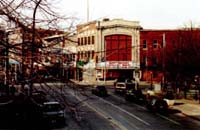
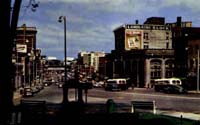
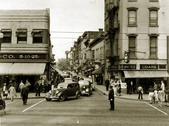
Ellis and Bucci Buildings
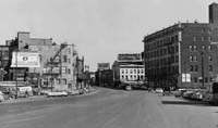
Fig 7.09 [enlarge]
View along Erie Boulevard towards State Street. Bucci and Ellis Buildings are on the far corner.
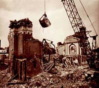
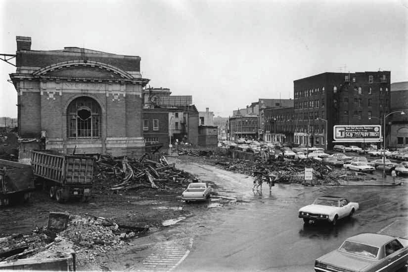
In 1969, as the city was getting ready to take over ownership of the Union Station to raze it and provide more downtown parking, it was also trying to take ownership of the Ellis and Bucci buildings on the corner of State Street and Erie Boulevard. The city's intent at the time was to extend the parking lot from Liberty to State Street, bordered on one side by Erie Boulevard and the other by the retaining wall for the raised train tracks. It was estimated that these two buildings would provide an additional 17-20 spaces. (9) The Ellis Building was built around the time that the Erie Canal was dug through that part of the city in 1825 and was considered to be one of the last surviving buildings from the Canal era. From the beginning, public sentiment was against the proposal. One local attorney who opposed the demolition of the buildings argued that it would "increase the size of the hole on our main street," and pointed out that the buildings "form a façade that gives our main street the appearance of a street rather than wasteland." (10)
By 1974, the city's Urban Renewal Agency [URA] had taken title to the Ellis building and was now insisting that these buildings make way not for a parking lot, but a "modern office building or a shopping complex." (11) But the city still felt that it would need the Bucci building to create a parcel that would be large enough to entice developers. The owner of the building, Earl Bucci, fought the city for years to prevent them from taking his property through eminent domain. The sentiment of the of the city was expressed by Councilman Ray Vacca who said, "Fight them" which was followed by Councilman Charles Seber who suggested that the city should "Demolish the building and let them take us to court." Councilman Erwin Shapiro thought that even though the building had three tenants, it looked bad and that "a vacant lot would look a lot better." (12) A number of residents continued to fight to keep the historic Ellis building and sent in an application to have it listed on the National Register of Historic Places. Wayne Harvey, vice chairman of the Schenectady Bicentennial Commission pointed out the irony of a city being nominated as a National Bicentennial Community while seeking to tear down so many buildings that were linked closely to the city's history. He said visitors could be taken to the site of the old train station or the Ellis Building to view the plaques and the pictures of what was once there and the city could say, "Isn't the plaque interesting?" or "Are not the pictures great?" The visitor would then be told by the city, "We had the building but we tore it down." (13)

But the city council remained determined to get rid of these buildings. One exception was Councilman David Roberts who thought that the city should at least have a proposal for redeveloping the properties before rushing to demolish them. Later he stated that he had "been 'besieged' by phone calls from residents all urging preservation of the building." (14) But after owning the building for a number of years and allowing it to deteriorate further, the city stated that they just didn't have the money to sustain the building. After years of protests (and urging) from residents to save the building, Councilman Erwin Shapiro admonished the "anti-demolitionists for 'doing a great injustice to the city. When you let the city spend a great deal of money to buy the building knowing that it was to be demolished, you've done a great disservice to the majority of the city taxpayers, you should have come forth earlier.'" (15)
The demolition contractor choose the first day of Spring in 1975 to begin the job. On the following day the Schenectady Gazette featured a picture of the Ellis Building being torn down with the caption titled: "Super Spring Cleaning." However, Earl Bucci continued to fight the city's attempts to take over his property, eventually taking it to the state's highest court. By 1976 the city was insisting that they needed both sites to attract a developer. The new plan: A rail transportation center with a 900 car parking garage. Soon after the city found a developer, the firm was indicted for fraud by the county, although the charges were later dropped. In the end, Bucci lost his court fight and the city started demolition in August 1978. Unfortunately the city was never able to interest a reputable developer in the site. Later modest landscaping improvements were later added — despite the mayor's protests; in the end the buildings were sacrificed for less than fifteen parking spaces. Plans being drawn up now would place an office building on the site as part of the new Western Gateway Transportation Center.
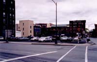
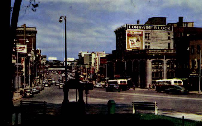
Lorraine Block

At the turn of the century, one of the more impressive buildings along the commercial section of State Street was the Lorraine Block. Built in 1902 by Welton Stanfords it was named in honor of his 14-year-old daughter Lorraine Stanfords. The building served as a "symbol of prosperity" until it was torn down to make way for the Albany Savings Bank. The newspaper headline in June of 1972 expressed the sentiment that was often echoed by city leaders when buildings were being torn down: "Symbol of City's Prosperity Falls Victim of Progress." In contrast to the highly ornamented white stone of the Lorraine Block, the new bank has no exterior ornamentation or detail and is made of a dark brick. Moreover, the new bank features a blank wall along State Street. Adjacent to the Lorraine Block was the Strand Theater, located between Clinton and Barrett Streets. A number of stars such as Roy Rodgers had played there, but in 1969 the city acquired the property through tax foreclosure and by 1972 had turned it into a parking lot. (16)
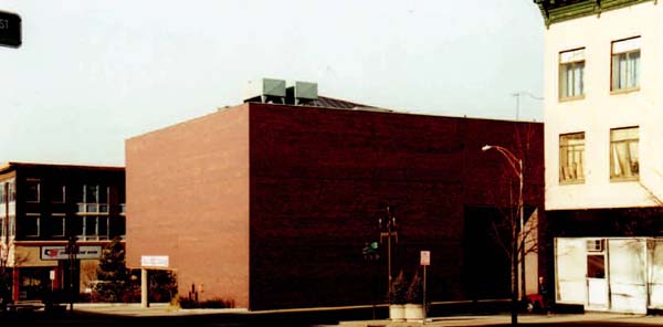
Fig 7.14 [enlarge]
New bank which was built on the site of the former Lorraine Block. With the symbol of prosperity now gone, the city shows its view of progress.
Nott Terrace High School
In August 1962, the once ornate south building of Nott Terrace High School lay in partial ruins, as the demolition contractor filed a suit against the city for removing some of the salvageable items he was entitled to. The building was left in that condition and residents complained of the eyesore. It had been part of the 22 Block area urban renewal project and was being removed to allow for Eastern Avenue and Liberty Streets to be aligned. In 1974, the north building of the high School was torn down after the realtor who purchased the property had been unable to sell the site to a developer with a building on it and therefore "demolitions seemed to be the only answer." (17) The site is now home to a Friendly's Restaurant.
Historic buildings of character and quality continue to be torn down in the downtown area today. Their demise is more often met by resistance, but the resolve of the city to get rid of buildings it feels are obsolete and not worth saving seems as strong as ever. At the end of 1999, a number of buildings on the corner of State Street and Broadway were leveled to make way for the new Department of Transportation Headquarters. Across Broadway from this site, the Hough Building, currently owned by the city, is quite likely to be the next target of the city and their busy demolition contractors.
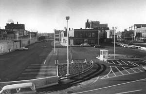
Center City

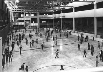
On June 24, 1979, the long awaited civic space that the city had been considering on and off since at least 1948 finally opened. It was part of a mall development that required the demolition of the Kresge and Grant buildings and was to include an ice-rink/exhibition hall as the centerpiece of a $3.3 million federally funded project. One of the primary reasons for the interest in it was that the city had discovered that federal money might be available for ice-skating rinks. The latest incarnation of the city's civic dream had been envisioned as a 3500 seat civic center with a regulation hockey rink that would serve as a public skating area as well as an exhibition hall where weekly events would bring thousands of visitors who would patronize the surrounding shops. (18) When the facility was built in late 1979 with seating for less than 500, the rink was not quite regulation size, the seats were only located along one side, the view from them was mostly blocked by large vertical supports and "the access in and out was terrible." (19) The events that were promised to those who had rented the new commercial spaces never materialized and the construction of their commercial spaces made heating them prohibitively expensive. The entire facility was in financial trouble almost from day one, and much of the promised public skating was scrapped in order to try to recoup some of the money by renting it out to youth hockey leagues. "But the project," one of the main components of the plan to revive the downtown, "was never intended to show a profit," the city manager reminded people, apparently alluding to its success. "The object," he continued, "was to draw people downtown where they would spend money in private businesses," an obvious admission of its failure (20)

Less than three months after opening with great fanfare and promise, the politicians were getting cold feet. Councilman Dom Gallo was saying that the facility was a "farce" and that he had been against it from the start while Councilman Jim Tedisco labeled the rink a "white elephant destined to bury the city in debt." (21) By the end of its first year, the city was unsure whether they would even be able to absorb the cost of the utility bills for the rink.
Recently, in a bid to save the city's financially troubled white elephant, a committee recommended melting the ice and using the space for other purposes. It is now rented out to indoor youth soccer leagues. Most of the retail spaces in it have long since closed. The interior, which was never finished, receives little maintenance and never had the open feeling or shine that the architects' renderings had suggested. A $200,000 climbing rock wall was recently installed which may help to compliment the rough look of the unfinished interior.
Canal Square
In 1978, it was reported that in two years "more than a full square block will have been converted from a decaying remnant of Schenectady's better days into an exciting, unique, specialty shopping center with covered walkways, open terraces, a winding canal or lagoon, and twice as much retail shopping space as at present." (22) Designed by the famous Washington architect, Arthur Cotton Moore, it was said that the "destiny of the downtown" was riding on its success. (23) The projects was envisioned as a great in-town shopping mall, which would connect a number of buildings on the 400 block of State Street from inside and create a pathway along the rear of the buildings.
Along the fronts, all the buildings were painted the same colors, dark brown with a mustard colored trim, to unify the block. An aluminum awning or signboard that stretched the length of the entire block allowed for only two distinguishing features to signify the uniqueness of each store — its name and the style of lettering. All other unique architectural characteristics of each building were down-played. Along the rear of Canal Square, a miniature canal was to carry paddle boats and customers along the backs of the shops to the main courtyard or square. To access the shops from the parking lots that were in the back, customers would walk over small rounded foot bridges. During the winter, they became too slippery, and had to be closed. The architect had failed to consider the harsh northeast climate. The canal itself was so poorly engineered it did not even last one season and began to leak into the basement storage areas of a number of buildings. A few years after the opening, the canal was filled in. Despite these flaws, the design got a number of awards including one from the Urban Development Action Grant [UDAG]. The day after Canal Square got its award, it declared bankruptcy.
Before it had even opened, the estimated cost to finish the project was more than $2 million over budget — A $2 million loan for finishing the project from the Urban Development Corporation was rejected months before the scheduled opening. Supposedly the architect/developer had done an economic analysis, but none of those involved from Schenectady were ever permitted to see it. Within days of the opening, the bank had foreclosed on the developer, and few of the second floor spaces were ever completed. Today, the there are only a few shops left in the entire development, and many of the infill buildings that were created, were so poorly constructed they will likely have to be demolished. An enclosed aboveground bridge or pedestrian walk was envisioned to connect Canal Square with the Center City. In the end, however, the only thing that linked the two projects was inadequate funding and poor construction. (24)
Fig 7.20 & 7.21 [enlarge]
The 400 Block of the Canal Square shortly after renovations.
In the years since, owners have gradually differentiated their buildings.
Conclusion
The city's quest for removing buildings to create parking has meant the loss of a number of historic buildings within the downtown. The extra parking combined with the loss of character and opportunities for retail spaces is a combination that has never brought the shoppers back to the downtown. The two major attempts at selected demolition and adaptive reuse — Canal Square and Center City were both essentially dead in the water before they began. Neither had the funding, or the construction management to allow them to be finished in a manner that would create any place of character. But all of these projects show a lack of longer-range thinking on the part of the city and are filled with faulty assumptions and outright bad guesses. And few of the projects seem to show any attempt to connect them through a common vision of what the downtown should be. In the end, many buildings were lost through all of these projects, millions in taxpayer money was wasted, and little of value was ever created.