[View 9x enlarged version (422K)]
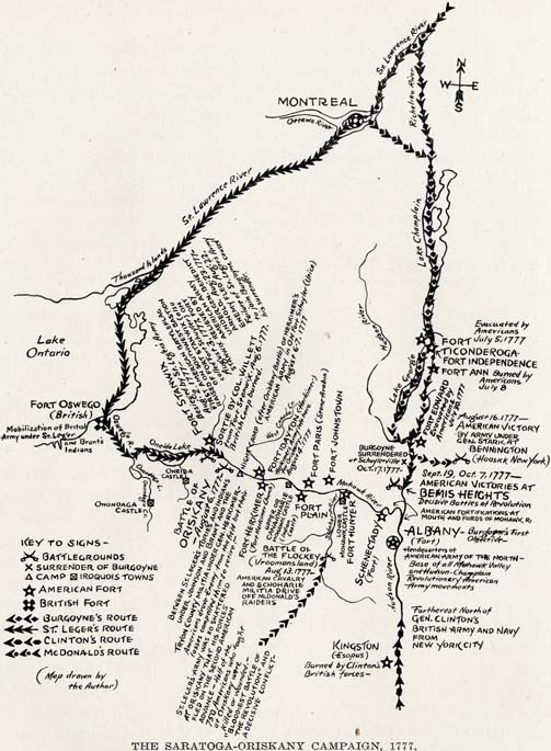
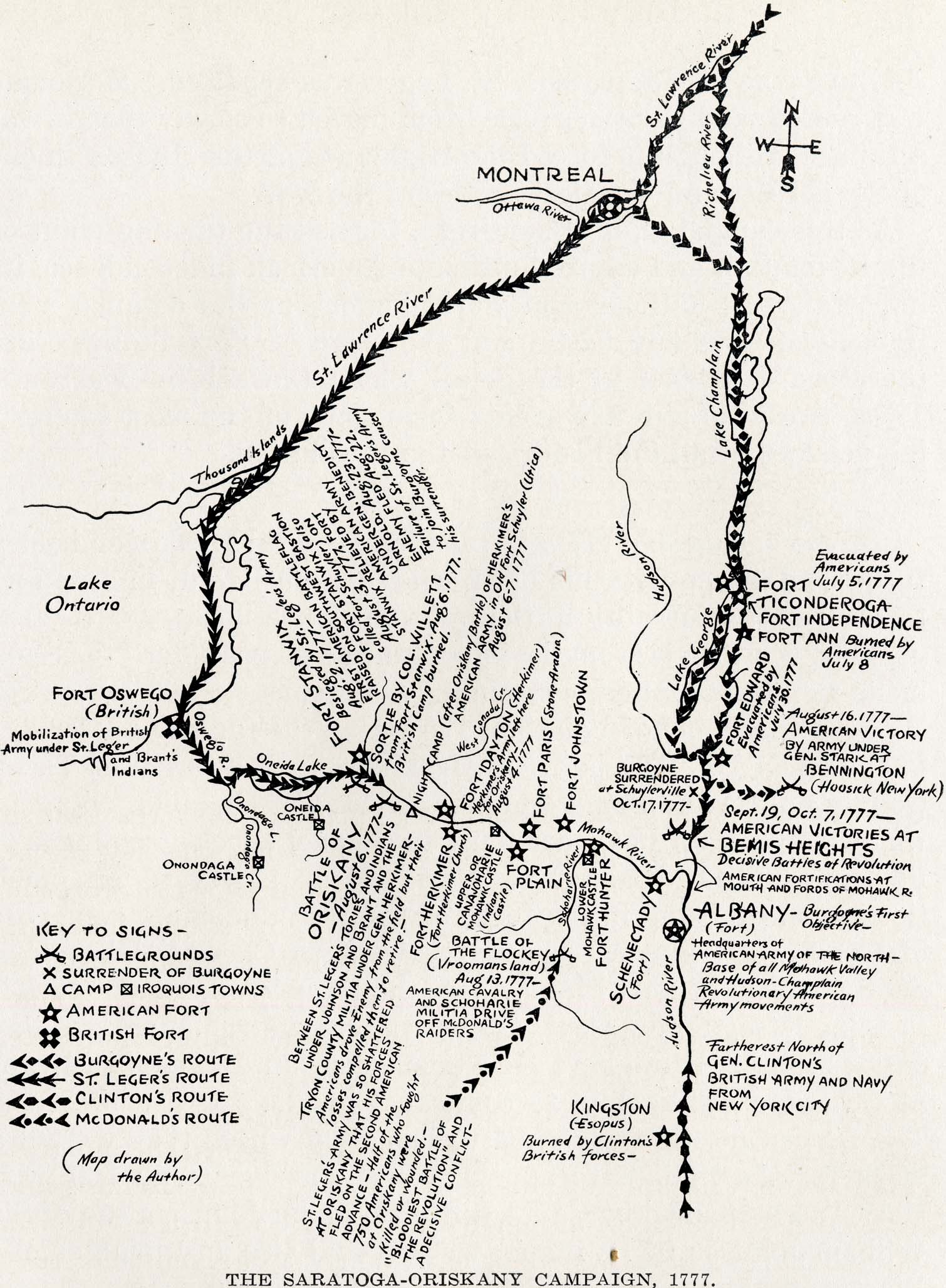
Map: The Saratoga-Oriskany Campaign, 1777.
Map showing the Burgoyne campaign against the State of New York and around the Mohawk-St. Lawrence-Champlain triangle. The American and British forts, the routes taken by the armies of Burgoyne, St. Leger, Clinton and McDonald's raiding party are plainly shown, together with the battlegrounds of Bemis Heights, Oriskany, Bennington, Vroomansland, and the sortie made by Colonel Willett's party from Fort Stanwix. All these actions of this decisive campaign of the Revolution were fought on the soil of New York State, including the battle of Bennington (the latter referring to a large district and not a town). American victories in this campaign on these battlefields won liberty for America. During this campaign the first American battle flag was flown to the breeze on August 3, 1777, and first flew in the smoke of battle during Willett's sortie, August 6, 1777.
This campaign was one of two decisive campaigns around the Mohawk-St. Lawrence-Champlain triangle. The other was the victorious one waged by General Amherst's American-British army for the conquest of Montreal and New France (Canada) in 1760. See the map in Chapter 49 and note the similarity of the enveloping movement, with the exception that Burgoyne moved against Albany while Amherst marched and sailed for Montreal. Both campaigns were made largely over rivers and lakes, and Burgoyne probably studied Amherst's campaign closely. The battles of Hubbardton and below Skenesboro are not shown as it would make the map confusing. They were American defeats but not decisive like the battles shown here.
Colonel Brown's attacks on the British outposts at the foot and head (Diamond Island) of Lake George are not given, because indecisive. The line indicated on Lake George represents movement of Burgoyne's supplies.
Map drawn by the Author
Key to Signs — shows symbols for battlegrounds, surrender of Burgoyne, camps, Iroquois towns, American forts, British forts, Burgoyne's route, St. Leger's route, Clinton's route and McDonald's route.
Other notations on the map include:
- (Fort) Albany — Burgoyne's first objective — Headquarters of American Army of the North — Base of all Mohawk Valley and Hudson-Champlain Revolutionary American Army movements.
- Furtherest north of Gen. Clinton's British army and navy from New York City.
- Kingston (Esopus) burned by Clinton's British forces.
- Fort Ticonderoga evacuated by Americans July 5, 1777.
- Fort Ann burned by Americans July 8.
- Fort Edward evacuated by Americans July 30, 1777.
- Fort Stanwix besieged by St. Leger's army Aug. 2, 1777 — first American battle flag raised on southwest bastion of Fort Stanwix (also called Fort Schuyler) on August 3, 1777. Fort Stanwix relieved by American army under Gen. Benedict Arnold, Aug. 23, 1777. Enemy fled Aug. 22. Failure of St. Leger's army to join Burgoyne caused his surrender.
- Fort Dayton (Herkimer) Herkimer's army left here for Oriskany — August 4, 1777.
- Battle of Oriskany August 6, 1777
- Between St. Leger's Tories and Indians under Johnson and Brant and the Tryon County Militia under Gen. Herkimer — Americans drove Enemy from the field but their losses compelled them to retire. St. Leger's army was so shattered that his forces fled on the second American advance. Half of the 750 Americans who fought at Oriskany were killed or wounded — "Bloodiest Battle of the Revolution" and a decisive conflict.
- Sortie by Col. Willett from Fort Stanwix, Aug. 6, 1777. British camp burned.
- Night camp (after Oriskany battle) of Herkimer's American army in Old Fort Schuyler (Utica) August 6-7, 1777.
- Battle of the Flockey (Vroomans Land) Aug. 13, 1777 — American cavalry and Schoharie militia drive off McDonald's raiders.
- August 16, 1777 — American victory by Army under Gen. Stark at Bennington (Hoosick, New York).
- Sept. 19, Oct. 7, 1777 — American victories at Bemis Heights decisive battles of Revolution.
- Burgoyne surrendered at Schuylerville Oct. 17, 1777.