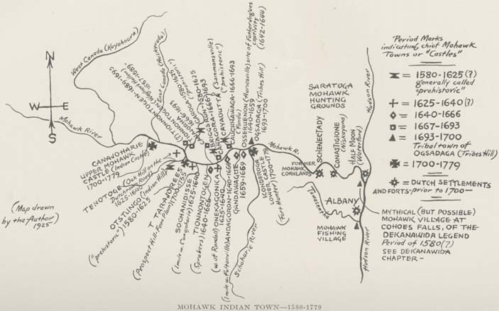
[View 4x enlarged version (99K)]
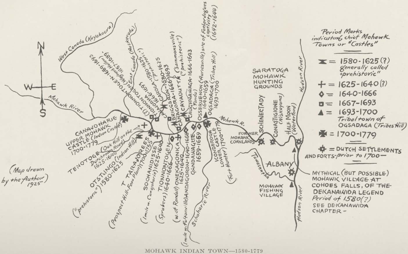
Map: Mohawk Indian Towns — 1580-1779. Map drawn by the Author 1925.
Chart Map showing location of the chief Mohawk Indian towns on or near the Mohawk River from the time of their migration from Canada and Vermont to the Valley about 1580, until the few remaining Mohawks were removed by Col. Van Schaick in 1779. The Dutch settlements and forts of Albany, Waterford, Niskayuna. and Schenectady settled prior to 1700 are here shown. Up until 1666, the dates here shown are all estimates; after that they are matters of historical record. See list of Mohawk Valley towns in Chapter 6.
Period Marks indicating chief Mohawk Towns or "Castles"
- 1580-1625 (?) generally called "prehistoric"
- 1625-1640 (?)
- 1640-1666
- 1667-1693
- 1693-1700, tribal town of Ogsadaga (Tribes Hill)
- 1700-1779
- Dutch settlements and forts prior to 1700-
Rivers as indicated on the map, roughly left to right: Mohawk River, West Canada (Kuyahoora), East Canada (Auskerada), Schoharie River, Tawasentha, Hudson River.
Town and other sites as indicated on the map, roughly left to right:
- Canajoharie Upper Mohawk Castle (Indian castle) 1700-1779
- Tenotoge (Oak Hill on the Dutchtown Road) 1625-1640
- Otstungo (Indial Hill) 1580-1625 ("prehistoric")
- Tarajorees (Prospect Hill-Fort Plain) 1700-1755
- Sochanidisse (1 mile west of Canajoharie) 1625-1640
- (?) Tionnontogen 1689-1693
- Tionnontogen 1667-1689
- Garoga 1580-1625 ("prehistoric")
- Briggs Run 1580-1625
- Canagora 1666-1693
- Tionnontogen (Sprakers) 1640-1666
- Onekagonka (west of Randall) 1625-1640
- Andagoron (1 mile west of Fultonville) 1640-1666
- Cayadutta (Sammonsville) ("prehistoric")
- Caughnawaga (Fonda) 1666-1693
- Gandawague 1659-1669
- Osseruenon (Auriesville, site of Father Jogues' captivity 1642-1644) 1640-1659
- Ogsadaga (Tribes Hill) 1693-1700
- Iconderoga Lower Castle (Fort Hunter) 1770-1779
- Schenectady
- Conastigione (Niskayuna)
- Half Moon (Waterford)
- Albany
- Mohawk Fishing Village
- Saratoga Mohawk
- Mythical (but possible) Mohawk Village at Cohoes Falls, of the Dekanawida legend, period of 1580 (?) See Dekanawida chapter